Wednesday, June 7, 2017

Cycling from Amsterdam to Maastricht (route LF7)

Amsterdam to Maastricht by bicycle
The Netherlands is a cycling paradise. Mainly because of the completely flat terrain, the Dutch are using the bicycle both as a recreation activity but also as the main means of every day transportation. Amsterdam, the capital is full of cyclists who go to their daily jobs almost exclusively by bicycle. The extensive and safe bicycle lane network also helps.

What is surprising, is that the same well maintained and comprehensive network exists all over the country. It is possible to cycle from any part of the country to any other part exclusively by bicycle and using multiple different routes!


The way how this works is with a set of numbered points. Every stretch of cycling path starts and ends to a numbered point. Several paths may start and end to a point, similar to the screenshot to the right. So just by writing down the points of the planned route, one can easily travel anywhere.

On top of that, there is a network of 7 routes, all with their own labeling, for long distance routes. They are using the initials LF (ie. LF7) and the distances range from 165 to 1300km! One of those routes is the one we decided to follow and starts from Alkmaar (few km north of Amsterdam) all the way to Maastricht in the very south of the country.


Amsterdam to Maastricht by bicycle
Comprehensive signpost
We followed the route LF7a (LF7b is the other way around, Maastricht to Alkmaar) which is 385km in total. The part from Amsterdam to Maastricht following this route is 317km long and we completed it in 4 days. We did not have any special racing bikes, just normal city bikes so we took it easy, enjoying the countryside. The route can be easily completed in 3 days and with racing bike in 2 but then half of the fun of enjoying the Netherlands is lost. We found that a few signs were missing but in a route of 317km and a few thousand turns, it sounds almost normal. When feeling lost, we checked the map on the mobile phone and quickly found the correct way.

It is a beautiful way to experience the Netherlands. The route took us through places that no car can go and within 317km we could experience the changing Dutch landscape, both in terms or architecture and nature. The route is themed "Oeverlandroute" literally  meaning River Bank route and the truth is that we crossed and were almost always next to rivers. It was quite fun crossing some of them by ferries and not so much fun missing the last ferry after a long day of cycling.

Along the river Vecht
Apart from the rivers, the route took us right through major Dutch cities like Utrecht, Den Bosch and Eindhoven but also beautiful tiny villages like Thorn in Limburg, Heusden in North Brabandt and Vreeland in Utrecht province. For the last part of the route, cycling next to river Maas, was almost exclusively in Belgium so we even got to cycle on a different country. And we also got to find some details of the Netherlands that go completely unnoticed, like some beach resort complete with beach bars, water activities, slides etc in Limburg or a village somewhere outside Eindhoven where transportation seemed to be done exclusively with Indian style tuc-tucs! We also used a ferry to cross one of the rivers that the ticket collector did not have enough time from one side to the other to sell all tickets so the captain technically delayed landing on the other side.. Many details like that made the trip a nice experience.

In Belgium!
At nights we stayed in beautiful B&B's of which the Netherlands is full of. And all of them come with parking facilities for bicycles! If you plan to follow that route, it is probably wise to book in advance so you are sure you will find a place to stay. Might be tricky during holidays in the Netherlands.

The experience was amazing and highly recommended. It is not as difficult as it may sound but having a good bicycle is essential. It does not have to be fast or anything, just reliable. The path is in excellent shape and very well maintained. Cafes, restaurants and super markets are in abundance along the way. A piece of advice if you plan to take the route is to take it easy and enjoy it. By planning to cycle around 80km per day, the route can be completed in 4 days which is a good enough pace. Oh, and also try to factor in the weather, which is almost impossible planning such a trip in advance. Still, be prepared for all kinds of weather at any season of the year :-)


Complete route as registered on a GPX file 

Sources
Cycling in the Netherlands: https://en.wikipedia.org/wiki/Cycling_in_the_Netherlands
Long distance routes: http://www.hollandcyclingroutes.com/long-distance-cycle-routes/oeverlandroute


Sunday, May 14, 2017

Visit to an authentic Dutch Windmill close to Amsterdam

Windmills in Holland
The Netherlands, among others things, is famous for its windmills. They dot the flat landscape
"De Onrust" windmill
and harness the power of the almost endless winds that sweep the country. Dutch people have realized the power of the wind as early as the middle ages and have build powerful windmills for a wide variety of functions ranging from water draining to sawing wood and grinding. They come in a variety of shapes and sizes and they have certain specificities for each region of the country.


Although some still in use, windmills today are mostly a tourist attraction. One of the most visited attraction in Holland is the famous Zaanse Schans, just north of Amsterdam which in 2015 received the highest number of tourists out of any other place in the Netherlands! Beautiful windmills can also be visited in the UNESCO World heritage sight of Kinderdijk, which is located around 2hr away from Amsterdam with public transportation.

De Onrust
Dutch bridge and windmill
One day in March, on our way to the Aviodrome airplane museum, and due to roadworks we were diverted through provincial roads. And along the way we found this beautiful windmill which we decided to check out. To our surprise, on the site was one of the volunteers who take care of it, named Thon. 

As most windmills in the Netherlands, this one is named "De Onrust". It was built in 1809 to pump water out of the nearby lake called Naardermeer. It is still in use, doing the exact same job! It is impressive to note that to pump out 1cm of water the windmill needs to work for 14 hours straight!

As we were curious how a windmill works and Thon was very eager to show us around we had what it turned out to be more than 1hr tour. The whole windmill was just for us, without any other tourists ever showing up. We got to learned the detailed history but also a live demonstration of how it works. Thon showed us everything about how the windmill start and breaks, how the sails unfold, how to turn it to face the wind etc. Having visited many windmills in the Netherlands, this is the first time we got such a detailed explanation. And it was completely for free, although a donation box is available which of course we gave some money which will help preserve this lovely site.

How to visit De Onrust
The windmill is located around 20km from the center of Amsterdam. It is an easy car drive or for the
Location of "De Onrust"
more adventurous, it is reachable by bicycle through a well planned network of bicycle lanes (see in sources for a tool to help you plan your bicycle route). Also public transportation is available but it is a long journey so not recommended.


The exact coordinates, in case you want to plan your route are:
52.315106, 5.091774 or 52°18'54.4"N 5°05'30.4"E

Thon, our guide, who was both very enthusiast and also spoke perfect English, is there almost every Sunday from 11:00 till 16:00 or by appointment to this email: thonstof@gmail.com


"de Onrust" is well worth a visit and it is a much more authentic experience than the extremely touristy Zaanse Schans. If combined with a bicycle tour it makes a fascinating way to experience the Dutch countryside..

Enjoy!

Sources:
  1. Zaanse Schans, the most visited attraction in the Netherlands in 2015: http://www.dutchnews.nl/news/archives/2016/04/windmill-park-zaanse-schans-attracts-most-foreign-tourists/
  2. Kinderdijk: https://www.kinderdijk.com/
  3. Aviodrome airplane museum: https://www.aviodrome.nl/
  4. Zaanse Schans: https://en.wikipedia.org/wiki/Zaanse_Schans
  5. Dutch windmills database: https://molendatabase.nl/nederland/
  6. Info about windmills (in Dutch): http://onserfgoed.eu/
  7. Plan a bicycle route anywhere in the Netherlands: http://www.hollandcyclingroutes.com/online-cycle-route-planner


Sunday, April 23, 2017

Trip to Belfast and N.Ireland

Visit to N.Ireland
While growing up in Greece during the 80's I always remember listening to horrible stories about a war that was taking place in a distant land called N.Ireland. Being interested in international history, I was always keen on visiting. Recently, with the Brexit being a few years away, we thought it might be a good idea to visit now as in a few years time we might require a visa which will
Irish countryside
make travelling a far more complicated process. And so we did! In the Easter of 2017 we visited this much troubled part of the UK. Our base was Belfast and rented a car to explore as much as possible of the province. Of course we could not go everywhere but we visited few key places, as described below. One thing we noticed in almost every place we visited, is how well the two communities, -Republicans and Unionists- are separated. In almost every towns and village the Republicans hoist the Irish flag in their neighborhoods and the Unionists the British one. And, of course, colorful murals dot the areas most affected by the Troubles. N.Ireland is much more than the political past as the countryside is beautiful and full of rich history.

Bit of history
N.Ireland is one of the four counties of the island of Ireland, Ulster. The other three, that form the Republic of Ireland, are Leinster, Munster and Connacht. For many centuries the whole island was part of the United Kingdom. Irish tried many times to gain their independence but were all unsuccessful. Amidst the 1st world war, they succeeded and therefore in 1921 the island was split into the Republic
Peace wall in West Belfast. Notice the lonely tree without fence.
of Ireland and the northern part that remained part of the UK. In Ulster (what is now Northern Ireland), the British population (Protestants) was the majority and a large percentage of the was Irish (Catholics). The two communities seem to have lived in relatively peace for some years although Catholics never enjoyed the same status as the protestants did. This caused tensions to built up. Belfast, being the capital of Northern Ireland, was the only city on the island to experience the industrial revolution and it was prosperous (Titanic was build in the famous H&W shipyards of Belfast). Catholics benefited little from this prosperity as the majority of the jobs went to protestants. To make matters worse, in order to get a public paid job, one had to swear an oath to the Crown, which few Catholics were willing to do. This led to virtually no Catholics getting jobs as policemen, judges etc.

Mural in West Belfast.
During the 1960, the whole world was changing. From the civil rights movement in the US to the May '68 events in Paris. This did not leave N.Ireland unaffected. According to many historians, the first incident of The Troubles started with the UK elections of 1964. The Catholics (or republicans or nationalists) managed for the first time to elect an MP in Westminster, Gerry Fitt. The Protestants (or unionists or loyalists) did not like that which led to the first armed conflict in 1966 when members of the UVF attacked catholic areas of Belfast killing 2 Catholics and, accidentally, a protestant woman. The catholic people, influenced by Martin Luther King, staged their own civil rights movement, demanding equality, housing and jobs. The center of those movements was the city of Derry (or Londonderry) and of course Belfast. 

Mural in loyalist area
The turning point was 1969, when serious rioting broke out in the Bogside area of Derry, the so called Battle of the Bogside. The rioting went on for 3 days and when it was apparent that local police could not handle the situation the British Army arrived on the island to take control. As weird as it may sound the republicans welcomed the army who thought would protected them from the aggressiveness of the unionists. Soon this changed as the army showed their real mighty. Amidst all that the IRA (Irish Republic Army) who had helped with the liberation of Ireland and had been defunct, become active again.

The next few years are marked with killings, bombings and atrocities from both the republican and unionist sides. The peak of The Troubles was 1972, when in a single year almost 500 people were killed, half of them innocent civilians. On a single day, Sunday 30 January 1972, the British Army opened fire to a peaceful march in Derry, killing 13 people. This event is known as Bloody Sunday.

The next highlight in the history of N.Ireland were the hunger strikes of 1981 resulting 10 dead
Bobby Sands
inmates, most notable Bobby Sands who was elected an MP in Westminster during the strike. Up until 1976 all IRA prisoners enjoyed a special status, similar to that of Prisoners of War (POW). After 1976 they were treated as common criminals, a status they wanted to be reverted. This is the reason that led them to start the hunger strike. The UK government, with Margaret Thatcher as a PM, at first did not satisfy those demands, but eventually gave in to all of them (the so called "Five Demands").

In the years between 1981 and 1998, violence continued and was even spread outside N.Ireland, mostly to the UK,
Republic of Ireland and Germany. In the meantime British and Irish government were trying to bring all sides on the same table and end what seemed like an endless cycle of death. The government of Tony Blair, managed to achieve that and the result was the Good Friday Agreement of 1998 which led to a multi-party government in N.Ireland and an agreement between UK and Ireland. Still today, among others, the agreement mentions that N.Ireland belongs to the UK until the majority of it's citizens want to unite with the Republic of Ireland. Only then, the UK government will facilitate the reunification process.

Mural in Derry
In all, the violence caused throughout the years of the Troubles left almost 3500 dead and more than 45000 injured, many innocent civilians from both sides. Since the Good Friday agreement, peace has been established and the communities are working together for a better future.

Most recently, and with the Brexit closing in, questions of what is going to happen with the border or the status of the Irish citizens have emerged which might destabilize the region again. Few people I spoke with, told me that no one knows what is going to happen. One thing I read is that the EU gives more money to N.Ireland for development than the UK government does Also the region receives the second largest amount of EU funding in terms of percentage of regional GDP behind Scotland.

Belfast
Belfast is the capital of N.Ireland, the most populous city and the financial center. It is rich in tourist attractions, like the Titanic Quarter, the Ulster museum, the beautiful city Hall. Since we did not have enough days, we skipped all those and focused on the Troubles history of the city. To do that we joined one of the walking tours which took us to West Belfast, one of the areas most affected by the Troubles.

West Belfast
To our surprise, there is still a huge fence separating the two communities, republicans and nationalists which is called Peace wall. It is very sad to see but this is the living history. We walked in both communities and watched the murals, some of which were too aggressive. One went as far as displaying burned bodies and comparing ISIS with Sinn Fein, one of the parties that rules N.Ireland. There was much blood and hate in the past but moving forward, those things need to be forgotten. Some parts of the fence were open but with massive gates and a buffer zone, that close every night or when there are tensions. In the buffer zone, companies operate where people of both communities can work together. The government plans to remove all fences completely by 2023.

Our walk ended in the city center which is pretty much like every other European city center, with lovely shops,
Beautiful wall painting in Belfast
restaurants and pubs. According to our guide, this is the place that the communities come together, if only they are convinced to leave their suburbs.

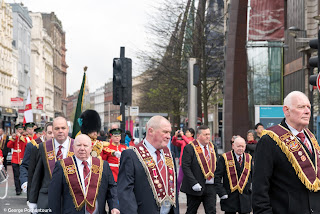
One thing also surprised us was that we came across one of the so called Orange marches.
Orange march in Belfast
These are walks by Protestants commemorating the battle of Boyne in 1690, when King William III (of Orange) defeated King James II and made Ireland part of the UK. Those marches built up on the 12th of July and are much hated by the Republicans. On that day, nothing happened but they marchers where guarded by heavy police force.

There is a lot of redevelopment going on in Belfast but still the past is difficult to forget.


Giant's Causeway
Giant's Causeway is the only UNESCO World heritage site in N.Ireland. It is almost an hour drive
Giant's Causeway
from Belfast and a very beautiful site. It is a unique geological formation, on the cliffs of Ireland. We happen to visit on an extremely windy day which made even walking difficult. Around the cliffs few walking trails are available with a variety of difficulty levels. For those with walking disabilities there is even a shuttle bus. The views are amazing and if you happen to visit in good weather, it is well worth taking one of the longer hiking routes. Entrance to the Giant's Causeway is 10.5 pounds.


Derry
Famous mural in Derry
The Bogside, Derry
As mentioned in the history section above, Derry was one of the centers of the Troubles. Nowadays it looks like a peaceful town with the Catholic and Protestant communities still living separately. It is well worth visiting the Bogside where a number of beautiful murals remind of the troubled past. There are a number of walking tours available but as we arrived late in the day, we could not join any of them so we wondered alone. It is highly recommended that you join any of these as they are inexpensive (around 4pounds p.p.) and have a lot to give. Of course murals are also painted on the unionist neighborhoods too which are on the other side of the Bogside. 

Derry is also famous for it's well preserved stone fortifications, which are the best in Europe! The city center, completely inside the fortifications, is very modern with lovely pubs and restaurants and good hotels.


Driving around Mourne mountains
Since we had a car, we decided to see some rural part of N.Ireland. One nice route is the coastal road around Mourne mountains, just south of Belfast. Dotted with beautiful villages and typical Irish nature, it made a pleasant drive. We started from the town of Warrenpoint, just on the border with Ireland and drove along the coast all the way to the Newcastle (apparently there are hundreds of Newcaslte's around the world, one of them in N.Ireland!). Undoubtedly, the most beautiful village along the way is Rostrevor.
Warrenpoint
In between the route, we stopped frequently to explore the surroundings. Most of the time, we spent in the so called Silent Valley which is formed around the reservoir providing water to most of Belfast. It is indeed very silent and a number of walking trails can take you around the reservoir of in a dense forest right in front of the dam.

Rostrevor
Our last destination before returning to Belfast was the seaside resort of Newcastle, a beautiful and busy town. What surprised us the most were the number of indoors entertainment centers for kids and the plethora of ice cream stalls and people queuing at them (it was freezing cold and rainy when we were there!).


For more pictures from N.Ireland visit my flickr album here: https://www.flickr.com/photos/gpahas/albums/72157681080758240

References:
- A Short history of The Troubles, by Brian Feeney, 2004
- Wikipedia
- N.Ireland and EU funding: http://bruegel.org/2016/05/northern-ireland-and-eu-funds/
- DK, Eyewitness travel Ireland, 2016


Monday, February 6, 2017

Bits and pieces from India

At the beginning of January 2017 I found myself once again on a plane this time to beautiful India. I had visited the southern town of Bangalore in 2009 for a friends wedding. For completely different reasons, I was once again visiting the same town, this time for work. I was with two colleagues and good friends, which always helps to make any trip a nice experience. Bangalore is the software development capital of India and many foreign and local companies have software delivery centers spread all over the city. Although it is an interesting place, what I will always remember from Bangalore are it's endless traffic jams. As locals always told us, distance is not measured in km's but in the time it requires to travel. And up to 1hr delay is not a delay, it is normal.

During the 2 weeks we were there, we had the chance to travel to the famous Taj-Mahal and New Delhi. As a bonus, we happened to be in India on the Republic day which is a public holiday and gave us a chance to take a short trip in the Karnataka province (of which the capital is Bangalore).

Agra
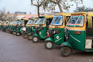
In order to get to Taj Mahal from Bangalore, we had to fly to New Delhi on a Friday evening and catch a train on Saturday early morning. There are several ways to get from New Delhi to the town of Agra (where Taj Mahal is located) but the train is probably the nicest. There are a number of trains leaving New Delhi train station to Agra Cantonment station, which vary both in quality and speed. The best option for us was the 6:00am to Bhopal Shatabdi. Tickets are easy to buy online on the IRCTC website, provided you know someone with an Indian mobile phone as it is required for registration (no clue why!). The 1st AC class is comfortable and nice breakfast is served (along with newspaper, a bottle of water and snacks). The journey is 2hr long. Upon arriving at the station, foreign tourists are encountered with persisting taxi and rickshaw drivers (who wont take NO for an answer). As always in India, we took a tuck-tuck, negotiating the price in advance. Upon entering the vehicle and until arriving at the Taj Mahal, the driver never stopped trying to convince us to hire him for the whole day. We always said no but this was not an option for him.

Getting off the tuck-tuck we quickly forgot the annoying driver and started walking towards the Taj
Tuck tuck's
Mahal we so much wanted to see. There is a big area around the monument where no diesel powered vehicles are allowed in order to preserve the monument. The options are either to walk or hire one of the available electric rickshaws. Walking is a nice experience as we got to see local people plus the nature including plenty of monkeys and squirrels!

The ticket system to enter the Taj Mahal is slightly different for foreigners and locals. As European (some Asian countries have an even different system) we were required to pay 10 times more than locals and the price includes a bottle of cold water, shoe cover for the main monument and a fast line for foreigners. It is a good deal and well worth it. We wanted to get audio guide but unfortunately there were not available. We regretted not having downloaded the Audiocompass application which is similar to the audio guide. The price is around 1euro for the day.

Taj Mahal
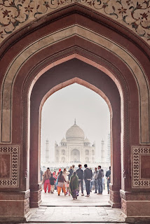
Entrance to the Taj Mahal
Upon entering the gardens of this majestic complex, there is a feeling of magic. Just a bit of history: The Taj Mahal, meaning Crown of the Palace, was commissioned in 1632 by the Mughal emperor, Shah Jahan, to house the tomb of his favorite wife, Mumtaz Mahal who died while giving birth to their 14th child. The tomb is the centerpiece of a 17-hectare complex, which includes a mosque and a guest house, and is set in formal gardens bounded on three sides by a crenellated wall. It is built next to the river Yamuna river. Apart from it's splendid Muslim architecture and magnificent decorations, it is a much celebrated monument for love.

From every angle and from every corner of the gardens, the monuments with its 4 minarets and its
distinct shape, stands out. We spend a good 2hours, visiting not only the main tomb but the nearby mosque and the small but nice museum. What stands out most from the Taj Mahal is the amazing work on the exterior and interior decorations. The whole monument is made from white marble and it is fully decorated with delicate patterns. Those are not simple paintings, but actually the marble is carved and the various stones are shaped and fitted inside the marble. It is amazing to realize the scale and effort put to complete such a piece of art!

The Taj Mahal
January in general is not a good month to visit the Taj Mahal as it is a known season for low visibility. It was not foggy but certainly visibility was not optimal for us. And Fridays it is always closed since it is prayer day for Muslims.

Agra Fort
A couple of km's away from Taj Mahal, is another beautiful monument also in the UNESCO World heritage list. Although there is an abundance of electric powered rickshaws, horse drawn carriages and bicycle rickshaws, we decided to walk. Remember to keep and show your Taj Mahal ticket if you don't want to pay twice an environmental tax that is applicable to both monuments but paid only once.

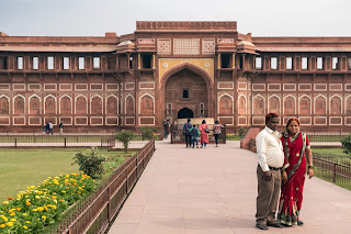
The Agra Fort was the residence of the Mughal emperors up to 1638 when this was moved to Delhi.
The walls of Agra fort
It is a massive fortress of various architectural styles. It is a walled fortress and it still stands in excellent shape with much of the original details preserved.

We spent another 2hours exploring the fort, astonished by the level of details, size and the carvings. The visibility had significantly improved and now we could see the Taj Mahal across the Yamuna river.


Agra
Agra
After our visit to the Agra Fort we decided to explore the city of Agra a bit more. We headed towards the Jama Masjid mosque, located near the Agra Fort. Apparently there are many mosques with the same name, not only in India but in the whole Muslim world. The city is not as glamorous as the monuments it is famous for. Around the mosque is a nice bazaar, full of shops that sell everything from textiles and shoes to mobile phones. Still it was amazingly noisily with all the cars, goats and cows squeezing between people visiting the market. The good thing was that since few tourists visit those places, we did not get the usual touts trying to sell us things or get us into their shops for souvenirs.

Family picture in Agra f
We ended our day around Sadar Bazar, another touristic place where we were chased by souvenir shop owners. Among all the stores we found a beautiful, quiet bookstore which was like heaven! One of the few places in India where we walked in and no-one cared about us. We could browse the books in peace and even buy a few nice souvenirs. The place was called Modern Book Depot and make sure you pay visit, if ever around.

After a long day we headed for the station to catch the 21:15 train to New Delhi which was delayed for almost 1:30 hours. Still it was fun sitting on the platform watching trains and sharing stories. Good thing we had booked a hotel right next to the New Delhi train station (highly recommended if you plan to visit Agra by train!) so it was a short 5 min walk.

New Delhi
Jantar Mantar
New Delhi is a big metropolis of 21.000.000 citizens, rich in culture and historical monuments. We had only one day to explore the town so we should make the most of it. Our visit coincided with the preparations for the Indian Republic day. This meant that the part of the town between the India gate and the Rashtrapati Bhavan (the President's residence), the so called "ceremonial axis" of New Delhi, was closed. Still, we could easily walk around the rest of the city, which we gladly did. We started around the famous Connaught Place, a circular market neighborhood designed by the British. To be honest it was impossible to enjoy it as we were constantly approached by shop owners who wanted to take us to their shop for souvenirs (and again would not take no for an answer). At some point there was one guy trying to convince us to walk to his store when another one came started walking with us, wanting the same thing! We realized that we would not be able to stay there long so we moved quickly towards the Jantar Mantar, an old observatory. This is a site of 13 massive astronomical instruments constructed around the year 1724. They were built by Maharaja Jai Singh II of Jaipur and were used both for astronomical and astrological purposes.

India gate
Our walk would then take us to the area where all the government buildings are located, the Rashtrapati Bhavan (the Presidents residence), the Secretariat building and the Parliament of India. As mentioned before, the entire area was mostly not accessible but still we could go around and explore the back alleys (we did not see the President's residence but we found the vice-presidents one :-)). A few hours later we ended up at the India gate, a war memorial for the Indian soldier who perished in the wars between 1914 and 1921 in far away lands (fighting for the British).

Next, we planned to visit the Red fort in the old part of the town but to our bad luck it was closed due
Busy streets of Delhi
to the upcoming celebrations. It used to be the residence for the emperors of the Mughal dynasty up to 1857 (this is the place they moved to from the Agra Fort mentioned above). It must be beautiful so if you make it there, post some pictures in the comments!

We ended up walking on the alleys of the Sadar Bazaar (same name as the one in Agra!) which was far noisier, messier and colorful. On the streets we walked we saw everything on sale, from electronics to jewelry, from second hand mathematics books to bridal dresses and from outdoors barber shops to made-up eateries. A truly authentic oriental atmosphere!

Jama Masjid, Delhi
Before catching the metro to the airport, we visited one last mosque, the Jama Masjid of Delhi, one of the biggest mosque in India and similarly named to the one we visited the previous day in Agra. It was completed in 1656 after 10 years of construction. The Mughal emperor who built it was Shah Jahan, the same as the one who build the Taj Mahal. It was quite impressive and at the time of our visit quite packed. There was a person at the entrance taking a 4euro fee from foreigners for taking pictures. Even if you don't have a camera or don't want to take pictures, you had to pay this fee if you are a foreigner. For locals, taking pictures is free :-)

Karnataka
Gommatwshwara statue
Back to our base, with the Republic day approaching, we wanted to get out of the city. From my last visit I remembered a public bus company, KSTDC that organized nice tours to historical places. We checked with our Indian colleagues and decided to book online a 1 day trip to some famous Hindu and Jainism temples. On the Republic day of 2017, we took the early bus to the town of Shravanbelagola to see the Gommateshwara statue, then to Belur  to visit the Chennakesava temple and finally to Halebidu to see the Hoyseleswara temple. It was a lot to see in one day but the temples were magnificent. Good thing with these trips is that they are well planned, with frequent stops in nice restaurants for breakfast, lunch and dinner.

Priest at the temple of Chennakesava
The first stop was at the Gommareswhara statue, a massive 17m high statue of the Jain God Bahubali. It is located near the town of Shravanbelagola. The bus drops us at the entrance, we take shoes off and start climbing the 600 steps to reach the temple. Indians, young and old seems to do in relative ease. The view from there is truly stunning. Endless forests of coconut trees with a few houses in between. The temple built around the statue was beautiful as was statue itself considering it is more than 1000 years old!


Next stop was for lunch, and we all decided to try butter chicken, truly Indian style. Of course it has little to do with how it is prepared in Europe. I was surprised that it is spicy!

Detail in Chennakesava temple
After the filling lunch, the bus stopped at the magnificent Chennakesava temple. It was build in the center of Belur, the capital of the Hoysala empire. As the name implies, the temple is dedicated to Chennakesava, a form of the Hindu god Vishnu. According to our guide, the temple took slightly more than 100 years to build! When looking at all the details carved into the stone, it is not difficult to understand why. There are literally hundreds of extremely detailed figurines carved out of stone and part of the temple. For being around 1000 years old, those details are extremely well preserved.

The last stop of our journey was the Hoysaleswara temple in Halebidu. This was very similar to the
Bull in Hoysaleswara temple
previous temple and apparently was build for the same empire when the capital was moved from Belur to Halebidu. It is dedicated to the Hindu god Vishnu and was completed around 1150AD. What stood out in this temple were the 2 huge bulls carved entirely out of stone. When leaving the temple I was approached by a young girl who wanted to sell me something. She kept asking for money but I explained I did not want to buy what she had to offer. When realizing I would not buy the item (don't even remember what it was!) she asked for a pen. "That is nice" I thought to myself, so I gave her the last pen I had. What I could not imagine is that many more children would come asking for pens! So if you plan to visit, carry some pens to give to those kids...

And with this, the exploring part of our visit to India ended. It was an amazing journey and really want to come back for more of India, perhaps in less touristic and crowded places. The people, the colors and the tastes are truly unique, making each visit an amazing experience. For more pictures from this trip visit my flickr account on this link: https://goo.gl/pQCFJS